Note:
this is the eighth in a series of occasionally appearing entries focusing on
deserts in general and the drylands of West Texas in particular
Western Texas hasn't always been dry...
Geologists say it was covered by a huge
inland sea during the Cretaceous Period which lasted from roughly 145 million
years ago until 65 million years ago. A
good chunk of modern North America also lay underwater while dinosaurs like
Tyrannosaurus Rex and Triceratops caused drier ground to rumble when they
walked. Pterosaurs likely glided through
the skies in search of aquatic meals along the edges of this inland sea which
stretched from the North Pole through the heartlands of modern Canada and the
United States, flowing into the current Gulf of Mexico...
 |
| A University of Michigan diorama envisioning the Permian Sea of 300 million years ago |
This sea quietly laid down limy sediment on
the ocean floor, century after century, and slowly eroded the Ouachita
Mountains which rose 300 million years ago to cross what is now central Texas. Then, 10 million years ago, comparatively
recently in geologic time, the Earth shuddered and pushed what had been a
limestone covered Cretaceous sea bed upward until it was a plateau in central
and western Texas nearly 2000 feet above sea level...
[One way to get a rough idea of the path
followed by the ancient Cretaceous sea would be to glance at a modern soil map
and look at the flow of ustolls across the Great Plains of North America. (Ustolls are a suborder of mollisols, a soil
order that generally form under grassland cover in semi-arid or semi-humid
climates. Parent material for these
soils is usually calcareous with limestone as an important component.) Many mollisols have strong agricultural
potential but occur in areas of limited rainfall. Taking advantage of their potential, sadly,
often requires crop irrigation in locations where water for human consumption
is already in limited supply.]
 |
| USDA soil map showing distribution of Mollisols in the United States. The Ustoll sub-order (in orange) roughly follows a path taken by an inland sea during the Cretaceous Period some 65 million to 145 years ago |
Nowadays, the plateau pushed up 10 million
years ago is called the Edwards Plateau.
Most authorities say it (and an aquifer in the region) took its name
from Edwards County which was organized in 1883 and named after Hayden (or
Haden) Edwards, a land empresario who lived in the East Texas town of
Nacogdoches before Texas won its independence from Mexico. Edwards held huge grants for land in the
western part of Texas but likely never even saw the area...
Edwards County is desolate country for those
who wonder. It sits a couple hours south
of the despoblados surrounding San Angelo and occupies 2120 square miles of
Texas with a population of 2002 during the 2010 census. Very few blacks or Asians live there and
approximately 45% of the people in Edwards County call themselves Hispanic. The Lipan Apaches hunted and gathered the
region when Spaniards decided to Christianize them by way of the Mission of San
Lorenzo in 1762. Neither Spain nor
Mexico had any real desire to settle the empty land. Anglos came a century later, seeking
opportunity...
 |
| Sparsely populated Edwards County, Texas, takes its name from the Edwards Plateau. This is a view south of the town of Rock Springs. |
Its earliest settlers of European descent
were smart enough to realize that country with an annual average rainfall of 22
inches does not make for good farming but can support a few goats and
sheep. Accordingly, Edwards County
became (along with the rest of the western Edwards Plateau and adjacent
Trans-Pecos) the nation's wool and mohair center. In 1940, Edwards County boasted 376,322
angora goats, 331,970 sheep, and 2993 humans at the zenith of its
mammalian population...
Hayden Edwards played an even more
significant role in Texas history than giving his name to a desert country
county in 1883, thirty-four years after his death...
This role had a name: the Republic of
Fredonia...
 |
| Flag of the Republic of Fredonia |
Fredonia, admittedly a short-lived republic
(from December 21, 1826 until January 31, 1827), was the first attempt by Anglo
settlers in Texas to secede from Mexico.
The George Washington of Fredonia was Hayden Edwards who came into the
area near Nacogdoches in 1825, lured by promises of great wealth in the form of
land grants from the Mexican government.
His contract called for him to bring 800 families to eastern Texas. Edwards made two really big mistakes in
building his colony: showing favoritism to already rich southern planters (he
was one himself) who wanted more land at the expense of poor white or brown "peasants"
(whom he looked down upon) and taking sides in a hotly contested local election. Mistakes of this sort generated enough
friction to convince the Mexican government to revoke his land grants...
Edwards had no intention of giving up and
returning to his plantation near Jackson, Mississippi. He'd invested more than $50,000 in the
project. (In simple purchasing power
terms, an 1825 dollar translates to about $24 today. An1825 dollar, however, translates to $660
now in terms of measuring "wealth" for social status or economic
"clout" purposes.) Few people
today would simply walk away from a $33,000,000 investment today and Edwards
had no desire to do so when it came to its equivalent back in 1826...
Declaring their independence from Mexico,
Edwards and his supporters proclaimed the Republic of Fredonia and attempted to
forge an alliance with local Cherokee Indians.
This did not work out well. Nor
did it help Edwards' cause that his fellow empresario, Stephen F Austin, then
had no quarrel with Mexico and agreed to supply men to fight alongside Mexican
troops to end the rebellion...
 |
| Hayden Edwards and his wife |
The Republic of Fredonia collapsed as its
leaders fled, not even attempting to engage in battle when lightly armed
soldiers arrived to quash independence.
Edwards crossed the Sabine River into Louisiana to avoid a trial and a
firing squad. He came back to Texas a
decade later to join the fight for Texas independence and to reclaim his role
as one of Nacogdoches' leading citizens until his death in 1849...
[Austin (whose own contract called for him to
receive 67,000 acres of land per every 200 families settled) provided 250 men
to end the rebellion after informing his colonists "infatuated madmen at
Nacogdoches have declared independence."
His contingent numbered 150 men more than the troops sent by the Mexican
government.]
Long before Hayden Edwards bit at the hand
that fed him and long before Cretaceous sea beds were covered with limy
sediment, the world was literally one...
 |
| Dimetrodon prowled the steamy forests of Pangaea |
About 300 million years ago, the world's land
masses coalesced into a single continent which modern scientists call Pangaea
("entire earth" in classical Greek) surrounded by a world ocean now
known as Panthalassa. These land masses
began to rift a hundred million years later.
[A German named Alfred Wegener, a man who would die exploring the icy
wastelands of Greenland at age 50 and son-in-law of the climatologist Wladimir
Koeppen, first proposed the idea of an "urkontinent" in 1915. The notion was too radical to be immediately
accepted and it took several decades for mainstream geology to take kindly to
Wegener's theories. ] This time of
global unity took place during the Permian Period...
The Permian gave its name to the Permian
Basin of western Texas and eastern New Mexico.
This area of drylands has one of the world's thickest deposits of rocks
dating back to the Permian Period, including the spectacular Guadalupe
Mountains with the highest point in Texas-- the eponymous Guadalupe Peak which
rises 8749 feet above sea level. The
mountains are also home to El Capitan, another hill towering above the
Chihuahuan Desert landscape...
El Capitan served as a landmark along the
Butterfield Overland Mail route from 1858 until 1861. Connecting Memphis and St Louis with San
Francisco, the Butterfield stagecoaches crossed into the drylands in the Concho
Valley of Texas before there was a settlement first called Santa Angela and
then San Angelo. It continued on to the
Pecos River and the eerily named Horsehead Crossing (where the skeletons of
animals trapped in quicksand or poisoned by briny river water lay scattered
along the banks of a once rapid and treacherous stream). From there it was on to El Paso and Tucson...
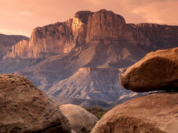 |
| Guadelupe Mountains National Park: home to some of the Earth's oldest rocks |
Likely, there would have been little or no
interest in the passenger and mail services provided by the Butterfield
Overland Mail if a carpenter named James Marshall hadn't been building a mill
for John Sutter near Coloma, California, on January 24, 1848. Marshall realized some shiny flakes he found
in the American River were gold. His
discovery set off a nation-changing rush for quick riches. Ironically, neither Marshall nor his friend
John Sutter, a Swiss immigrant, staked producing claims. Both men died in poverty, their businesses
ruined by trampling hordes of greedy men...
Gold in California in 1848 meant Statehood for
California in 1850. It also meant
roughly 300,000 new residents pouring in to search for gold. Many came from East of the Mississippi,
leaving Atlantic ports on ships forced to round the southernmost tip of South
America because there was no canal dividing Panama...
By 1856, California, still new to the Union,
threatened to secede if Congress failed to build a transcontinental railroad. Our legislators dickered costs (then as now)
and a frustrated U S Postal Service let bids for a $600,000 contract-- won by a
56 year old New Yorker named John Butterfield who was also a founder of current
day American Express-- for an overland mail coach service which would guarantee
25 day coast to coast service until Congress agreed to build a railroad...
 |
| Guaranteed trans-continental mail delivery and passenger service in the United States began with the Butterfield Overland Mail. Its route crossed much of the Southwest Desert country from West Texas through New Mexico, Arizona, and California. |
LRNARTS MARKETPLACE:
Prints and greeting
cards by Louis R Nugent available through Fine Art America. Choose from nearly two hundred unique ideas
for home and office decor or holiday and birthday cards for someone who
deserves something out of the ordinary.
Individual cards can be purchased for under $5. High quality print prices start at $22.
Follow and Like Louis R Nugent Photography on Facebook @ louisnugent22.
Fine Art America now
features painting, drawings, and photographs by fourteen artists who celebrate
the majestic and uncompromising landscapes, settlements, people, plants, and
animals of West Texas. Claim your part
of a rugged, beautiful and dry corner of America's Southwest:
Fine Arts America now
features work celebrating the mysterious
and lovely Bayou State of Louisiana and its unique lifestyle:
http://fineartamerica.com/groups/cajun-country-louisiana.html
CREDITS
Note:
All photographs for this essay were located through Google Images or Wikipedia,
without authoritative source or ownership information except as noted: Edwards
County south of Rock Springs photographed by Billy Hathorn 2011;Permian Sea
diorama from the University of Michigan Museum of Natural History; soil map
from United States Department of Agriculture; Guadalupe Mountains National Park
from National Geographic. Readers
interested in a more detailed account of Tom Green County soils can find the
1976 soil survey online at http://soils.usda.gov/survey/online_surveys/texas/TX451/tomgreen.pdf. Roadside
Geology of Texas by Darwin Spearing
(Mountain Press, 1991) provides a useful and layman friendly survey of Lone
Star State landforms.
No comments:
Post a Comment