Thursday, December 29, 2011

Five Desert Plants


Creosote Bush (Larrea tridentata) can be found in the "hot" North American deserts... the Mojave, Sonoran, and Chihuahuan.  Some authorities consider it the hardiest of the continent's dry country plants due its ability to endure two years of 100 degree plus temperatures with zero precipitation.  One colony in the Mojave is estimated to be over 11,000 years old.  Creosote bush leaves consist of two wing-shaped leaflets.  Botanist Michael Powell, an authority on Southwest Texas trees and shrubs, lists the plant's Texas distribution as the Trans-Pecos and Western Edwards Plateau...


Creosote Bush


Tarbush (Flourensia cernua) and Lechuguilla (Agave lechuguilla) are not found growing in non-cultivated status outside the Chihuahuan Desert and are considered "indicator" plants.  Like creosote bush, tarbush generates an aroma reminiscent of petroleum distillates.  Lechuguilla serves as the source for tequila and is sometimes known as "shin-dagger" for its razor sharp leaves capable of impaling any man or beast unfortunate enough to fall into it....


Tarbush


Lechuguilla

Javelina Bush (Condalia ericoides) follows the outlines of the Chihuahuan Desert as well.  Unlike creosote bush and tarbush, javelina bush is a spiny shrub that produces bright red drupes.  Biologist Vernon Bailey noted its presence in the Concho Valley as he traveled through the area in 1899.  Using his notes, I was able to locate a stand of this attractive desert-dweller growing not far from the somewhat misnamed Water Valley area of northwestern Tom Green County where it competes with Yucca reverchonii...


Javelina Bush

Woody Crinklemat (Tiquilia canescens) is also commonly known as Dog Ear.  Like creosote bush, this sub-shrub dots desert landscapes throughout the Mojave, Sonoran, and Chihuahuan Desert regions.  It prefers limestone or calcareous soils... 


Woody Crinklemat


Note: all photographs copyrighted by Louis R Nugent

Monday, December 26, 2011

A florist shop, tree yuccas after a rain, and a walking trail by the Concho River...


Note: All images copyrighted by Louis R Nugent

Thursday, December 22, 2011

A Brief Visit to Mason County...

"West of Mason county, but few hogs are raised, because  there are few oak trees and but little 'mast,' besides there are no fences to keep hogs away from the crops."-- S B Buckley, State Geologist for the State of Texas, 1876

Mason County sits at the edge of the Texas Hill Country, almost equidistant to the state capital of Austin at 95 miles and the semi-arid desert country town of San Angelo at 106 miles.  With annual average rains of 25 inches and a 217 day growing season, the county has just enough precipitation to make farming a reasonably successful venture in non-drought years...

After Texas became part of the Union in 1846, settlers of European descent began pouring into the frontier areas first occupied by Apaches and then by the even more war-like Comanches.  To protect these settlers, the United States Army built a string of forts separated by a day's horseback ride.  These forts stretched from the Red River to the Rio Grande.  Brevet Major H W Merrill selected the site for the future Fort Mason because of its location between the San Saba and Llano Rivers...

Formally established in 1851, Fort Mason produced more Civil War general officers than any other military installation of the time.  Its last commander prior to the outbreak of hostilities between the North and South was Colonel Robert Edward Lee who, after a profound struggle within his soul, reluctantly resigned his commission in the Union Army to join the Confederacy...

Chamber of Commerce Brochure


Roughly a year after S B Buckley commented about the lack of hogs in the area, a young cowboy became the first victim in the Mason County Hoodoo War.  This exercise in frontier violence had its roots in resentment felt by settlers of Anglo-Scots descent who had come into the area from the Southern states towards German settlers who populated the region thanks to land grants approved by the Texas legislature.  The Civil War only chafed blisters more since the Germans remained overwhelmingly loyal to the Union.  Suspected cattle rustling triggered several years of murder and masked riders and mayhem (and lawmen gone bad) that ended as suddenly as it began when a leader of one faction died suddenly of "brain fever" while dining in a hotel restaurant on a visit to the nearby town of Fredericksburg...

One of the minor participants in the Hoodoo War was one John Ringo, accused but acquitted on charges of murder.  Brooding and quick-tempered, Ringo left the area and crossed the desert country of West Texas and New Mexico until he settled in the arid hamlet of Tombstone where he allied himself with the Clantons against the Earps and their allies.  Ringo's death in a remote Arizona canyon remains one of the great mysteries of the Southwest.  Was it suicide or murder...


Note: Brochure published by Mason County Chamber of Commerce, Mason, Texas..

Monday, December 19, 2011

Cactus Pads


Caliche and Desert Grasses

Grape Creek
Three from the Gallery...

Note: All images copyrighted by Louis R Nugent. Two of these experiments in light and color have appeared as "Pictures of the Day" on my Facebook account.

Sunday, December 18, 2011

Still Waitin', Aura...

1952 was an eventful year.  The United States attempted to obliterate Eniwetok Atoll in the Pacific Ocean with the first Hydrogen Bomb, archaeologists excavated the ancient city of Jericho where Joshua "fit a battle" as the sun stood still, Elizabeth II and Hussein ibn Talal ascended to the thrones of Great Britain and Jordan, Hank Williams bemoaned his travails because of "Your Cheatin' Heart"...
Perhaps the greatest event of that eventful year took place on the night of July 7th as highway worker Truman Bethurum pulled to the side of the road for a quick nap as he left a job at Mormon Mesa in Clark County, Nevada.  We link to a skeptical account of Truman's subsequent adventures with the sexiest interplanetary spaceship captain ever after a group of little space men in bus driver type uniforms cheerfully informed him that "we will take you to our leader."  In his defense, we point out that Truman's wife (who initially thought her husband had simply gone nuts) eventually filed for divorce, citing Captain Aura Rhanes of the planet Clarion which is just beyond our Moon as co-respondent in the petition...
Bethurum was one of many "contactees" in the 1950s and 1960s who claimed repeated visits from space brothers who looked entirely human.  The alien messages followed common themes... mankind must stop nuclear testing, give peace a chance, end wars, live in harmony with the earth, its creatures, and one another.  A handful of contactees impressed doubters with their obvious sincerity and belief in their own bizarre stories.  Sociologists studied them and their followers to see what the phenomenon said about these spiritual ancestors of the hippie movement...
Aura Rhanes promised to return to our primitive world one day.  Truman lived out his days, waiting faithfully for the return of the drop-dead gorgeous space babe who was clearly more than some bored interplanetary June Cleaver hopping into her death-ray equipped flying saucer to zip down to the Jupiter Mini-Mart for eggs and milk.  She was an empowered woman entrusted with the mission of changing the fate of a self-destructive world.  Feel free to come back, Aura.  Truman may have passed on to a higher plane, but, should I head out Mormon Mesa way, I'll wait for you...

More about Truman and Aura can be found here:


Note: Images this post are taken from the Google Images collections with no copyright information provided.  They are presumed to be in the public domain.


Truman Bethurum, circa 1953


 Aboard a Flying Saucer
Captain Aura Rhanes of the Planet Clarion

Friday, December 16, 2011

Holiday Time In The Desert...
Humans are a most adaptable species and holidays enjoyed in the larger culture can take on distinct regional flavorings.  Many folks have sought, often in the name of political expediency, to define the United States as a Judeo-Christian society with the emphasis being on the latter half of the adjective...
Not many opportunities to enter dreidel spinning contests in Southwest Texas come this, or any other, time of the year...
But despite that, the Concho Valley is pretty much the same as any other place where Santa arrives on a freight train decked out in holly wreaths, mermaids named Pearl tease us with siren smiles as they try on their red Christmas caps, and snowmen are thorny little rascals...


Pearl, by the by, lives in the Concho River.  Although she's never actually been seen by anyone and is a scientifically impossible fantasy, no self-respecting Angeloan would actually deny her existence.  Our aquatic temptress takes her name from the little purple pearls that are unique to the Tampico pearly mussel, a freshwater species found only in the Concho Valley.  Spanish explorers stumbled across a River of Shells circa 1650 as they tromped the desert in search of cities of gold.  In 1654, Diego de la Guadalajara was dispatched to the area around present-day San Angelo to collect as many pearls as possible. The story goes that the conquistadores brought back some of these treasures to Spain where they became part of the Crown Jewels...
The "snowman" in the picture with Santa in a Stetson riding across a snowy desert is part of a holiday display on Concho Street in front of the establishment of a vintner known locally as Mustang Sally.  He's made of twisted strands of Allthorn, a spiny little booger also known as Koeberlinia spinosa.  The plant is native to the dry country of the western Concho Valley and Trans-Pecos regions of Texas and pretty much resembles tangled barbed wire.  Other common names include Crown of Thorns and Crucifixion Thorn.  Not recommended as an ornamental on the grounds of a nudist colony...


Note: All images this post are copyrighted by Louis R Nugent

Wednesday, December 14, 2011

For some who have never had the chance to explore, life is sometimes defined by the places of their births.  Others become products of their travels.  These photographs are, in a sense, mini-diaries of  personal memories that are rarely articulated... 


Paris...


the southwestern desert country...


the Louisiana wetlands...


the California Coast...


Note: All images this post are copyrighted by Louis R Nugent. 


Tuesday, December 13, 2011

Henry's Restaurant, San Angelo

Note: All images copyrighted by Louis R Nugent

More Desert Than Not

Texas west of the 100th meridian and south of the 32nd parallel tends to be more desert than not.  Exactly how much is desert can be (and has been) debated.  But when all is said and done, the fact remains that Southwest Texas is hot and dry.

Historians and natural scientists tell us the pre-settlement Concho Valley was basically prairie country.  Accounts by Spanish explorers such as Juan Dominguez de Mendoza and pre- Civil War U S Army surveyors do much to support this theory.  Early descriptions rarely mention mesquite and say the creeks were filled with rushing water. 

But they also contain hints about the true character of the Concho Valley.  As LT Francis T Bryan traveled past Brady Creek in the spring of 1849, he described the grass as "abundant and good for grazing."  Not too many days later, he saw the grazing conditions near Dove Creek as only "tolerable...the grass being old and dry."

Bryan was one of the first people to notice there are actually two Concho Valleys.  One lies east of San Angelo and the other is west of town.  These two valleys exist because rainfall in Texas gradually decreases as one travels from the border with Louisiana to the one with New Mexico.  Annual rainfall averages culled from the Texas Handbook Online paint a clear picture of the land's increasing aridity:  Mason County: 25"; Concho County: 23"; Tom Green County: 18.2"; Reagan County: 16".

An 1876 report on Texas agricultural and mineral resources by geologist S B Buckley comments on precipitation in various parts of the state.  His totals roughly correspond to current figures.  Average regional rain totals were likely not much different during LT Bryan's day.

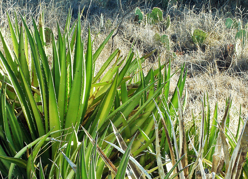
When naturalist Vernon Bailey passed though the Concho Valley in May 1899 he described the San Angelo area as "an open mesquite plain in the genuinely arid region" boasting "great stretches of smooth surfaces with only short grass and little desert plants."  Bailey's list of plant life on the road to Sterling City could have been written today: juniper, lotebush, wolfberry, catclaw, cactus, mimosa, agarita, yucca, and javelina bush.  Two years later, Harry Oberholser traveled from San Angelo to Ozona and saw the same species, adding joint fir and Mexican persimmon to the list.

A Bureau of Soils survey of West Central Texas conducted in the 1920s summarized the area as mainly "grasses and a few small trees."  The surveyor's catalog of important regional species echoes Bailey and Oberholser and also includes creosote bush, tarbush, and allthorn.

This emphasis on vegetation is meant to illustrate an important point:  the basic character of a place is reflected in its plant life.  Grasses, shrubs, and trees have no choice but to adapt to their environment.  Humans and animals can move from one place to another.  A plant can't.

These reports show that Chihuahuan Desert scrub has been part of the western Concho Valley landscape for over a century.  Archaeological evidence tells us mesquite grew here hundred years before the first rancher of European descent arrived.  

West Texas shrubs and grasses deal with erratic and irregular rains.  Focusing on Tom Green County, we have fifty-four years of Irrigation Technology Center data that puts San Angelo's average annual rain and snowfalls at 19.20".  But this is offset by a potential evapotranspiration rate of 71.34".  In short, the city enjoys semi-arid desert conditions. 

National Weather Service records generate a somewhat higher annual average of 20.91" at Mathis Field.  Data from 1977 to the present show our actual totals were as low as 12.95" in 1977 and as high as 32.05" in 2008.  The variation between average and actual is even more pronounced when we look at individual months during those same thirty plus years.   A hodgepodge of numbers ranging from 0.12" to 11.24" results in average monthly rains of 3.09" for May.

Our rains are not only infrequent, they are generally ineffective.  A statistically average year sees almost a month's worth of falling moisture but an inch or more of rain will come only four times.  To gauge the usefulness of our precipitation, we also have to factor in the drying power of the area's steady wind and high percentage of solar radiation received by the ground here.

Let us not forget water loss through plant transpiration.  The quality of our soils plays a role too but we can be thankful they are a bit more suited to farming and ranching than the dirt west of the Pecos.

Mother Nature made earning a living from the land hard enough but we didn't help her.  Land bordering on being desert country was pushed into that status by overgrazing newly fenced rangelands, controlling wildfire, and the introduction of prolific non-native species like salt cedar.

An 1898 Agriculture Department study by H L Bentley estimated that, in the decade prior to his report, 64 head of cattle were being grazed per square kilometer on ranges in this part of Texas.  Such overgrazing increased soil compaction and disrupted soil structure which, in turn, led to higher runoff rates and more water loss.  Animal hooves trampled grasses that spread via surface runners and further increased the amount of bare soil.  

Damage caused by overgrazing was not immediately obvious.  But, over the course of several decades, the number and size of woody plants increased across the western Concho Valley and Trans-Pecos grasslands.  Relatively low value tobosa grass filled a void left by the buffalo grass killed off by too many hungry animals in too small a space.  Degraded grasslands transformed into a collection of mesquite, prickly pear, and yucca separated by bare soil and patchy weeds.

How do we deal with the future water needs of the Concho Valley?

We can start by understanding that a number of long range climate forecasts for West Texas call for gradually increasing temperatures.  A few optimists see slightly more rainfall in our future.  This best case scenario means our aridity level will remain roughly the same.  But, should we see the same amount (or less) in the way of precipitation, there will be little debate that we are a bona fide desert.

We can realize that West Texas rainfall averages are just that-- averaged numbers.  These numbers do not always correspond to a consistent pattern.  It is true that we get rain in the spring and autumn months when warm and cold air masses collide.  But we don't know when or if this will happen in a given year.  In short, the sooner we stop telling ourselves that we "should be" at X inches of rain in May or Y inches in November, the better.

We can carefully think through any future plans to "restore" the land to its "natural" state.  Don't forget that salt cedar was introduced to help protect our rivers and streams.  Razing every pencil cactus and desert sumac in Tom Green or Irion County might create a nice dull landscape but it won't make the rain any less sporadic-- or the heat less intense.

None of these "we can dos" will solve our water problem.  But they can help change the way we think about the issue.  And that might help us all in the long run.   Turning a blind to eye to the degraded rangelands and brush-clogged streams is not a wise option.  Fixing them properly means we take the reality of our environment into account.

Some say we should pray for rain.  I am not convinced we should ask God to change a perfectly good design for the universe because we are unwilling to use the resources that we have been given more wisely than we have.  There is a reason giant yuccas and century plants can grow here.  It is because our part of the Concho Valley is a hot and dry land, more desert than not, a transition zone where short steppe grasses become the outer edges of the Chihuahuan Desert.  And it has been that way for a long time.